The best hikes and probably the most accessible can be found on the North entrance to the “El Yunque” Tropical Rain Forest, Puerto Rico. Road 191 it is very accessible from the Interstate PR 3 Highway. Just follow the signs to “El Yunque” National Park, “El Portal” visitor center. You can find more info here. After a few kilometers, on the right, you’ll find the entrance to the visitors center, witch is opened from 09:00 to 17:00. The entry fee in march 2014 was 4$/person. Here you can find the information center (ask for a hiking map if they don’t offer you), restrooms and a small souvenir shop . They also have a place where you can find some food and drinks if you didn’t pack some before.
If you don’t need any of this, that’s fine, you may not even enter the visitors center. Just follow the Road 191 witch continues 13 km. See map below: There is a barrier at km 8.1 at La Coca Falls witch closes at 18:00, so be sure to exit before that, unless you are planning to stay up there over night! We’ve seen some small camping places, but i think you need a permit for that. The first two stops on the road are very easy to reach from the car. First, La Coca Falls, on the right side of the road at km 8.1. Nothing fancy. Then, a little more way up (km 8.9), there is a tower on the left side. You can go to the top where you can have a beautiful view over the forest. At the base they also have some souvenir shop and some refreshments. A couple km after this you can find the parking for “Big tree” trail and “La Mina” trail.The Big Tree Trail is a 0.7 miles (1.4 km) self-guided interpretive trail, descending from 1,804 feet (550 meters) to 1,640 feet (500 meters). Hiking time is approximately 35-40 minutes, one-way. The trail is rated as moderate in difficulty (I’d say easy), and is steep in some places. It is asphalt paved throughout and several rain/picnic shelters are located along the way.You can find some stairs and railings along the way. We’ve parked the car here (parking lot at km 10.2) and we left on the trail. The La Mina Falls was nicer than La Coca; there were already some people in the small pool. After a few minutes we’ve decided to continue our exploration and moved on, up the river.From La Mina Falls, if you continue the road ahead you can find The La Mina trail witch is the most popular. The trail (witch starts at km 11.8) follows the course of the La Mina River downward through lush tropical trees, shrubs and flowers to the La Mina Falls. Along the way, it crosses and re-crosses the rushing river on many small bridges, passing tiny cascades and still pools filled with chilled mountain water, on its way to the falls. On this two trails there were a lot of tourists, of all ages, especially on our way back, so be sure to come early if you don’t wanna intersect to much with tours and other slow/noisy people… We started this trail at 10 o’clock. The the information center they said that the approximate time for those two trails is 35 minutes each (one way). We made it (both trails) in 50.
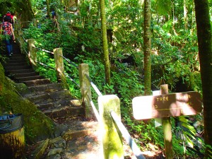
At the end of this trail you’ll exit a couple km up the road (km 11.8) where you can find a parking lot, rest area, gift shop and restrooms. This is also the starting point for other trails, Baño De Oro, Caimitillo and El Yunque trail. We did the last one. The trail begins at the concrete steps across from the visitor center, leading to the Baño Grande pool. At the top of the steps the trail turns right and proceeds along the Caimitillo trail for approximately 150 feet to the El Yunque trail junction (marked by a Forest Service sign). Continuing on, you’ll pass through the lush canopy of the Palo Colorado forest into the higher elevations of the Mountain Palm (Palma Sierra in Spanish) forest, eventually reaching the mysterious, ever-clouded Dwarf Forest at the trail’s end. Trail surface is a composite of asphalt, gravel and native stone, and can be muddy in places. There is a rain shelter mid-way along the first half of the trail. Estimated time from the information center: 2 hours. Our time: 1 hour 20 minutes.
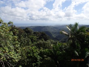
Unlike the other day, here you can find signs for every trail, you can’t miss the path. We’ve seen just a few people on this trail, much less than on the previous two. The trail is well maintained, they were even doing some works along it, fixing the stairs and draining tubes. At the end of it, the satisfaction is guaranteed, the view from the top is awesome. Just before reaching the peak of El Yunke, on the right side of the road, 10 steps away you can climb (be careful, it might be deadly if you fall) a cliff from where the view makes you feel in paradise.The green tropical forest underneath you bounded by the unreal blue beauty of the Caribbean sea and the wind gently touching your face gives you the sensation of “the world is mine”!
Walking a little more literally through the clouds, we’ve reached the peak of El Yunque. A small tower can be found here along with some communication antennas. I had the best AT&T network signal ever!
This was the only place where rain came, but luckily for us, it only rained on the other side of the forest and not for a long time.
Following the road back down, we made a small detour to the Mt. Britton lookout tower, witch was very similar with the first one on the road. The road is closed for cars at km 13. Heading back to the car we took once again La Mina trail, where we’ve stopped for a small bath in the river, and than Big Tree trail to finish from where we started this beautiful and amazing trip. It was around 17:00.
In conclusion, whenever you travel there, this is a part of Puerto Rico that you don’t wanna miss!


Mar 26 2014
Hiking in Puerto Rico (part 2 of 2)
The best hikes and probably the most accessible can be found on the North entrance to the “El Yunque” Tropical Rain Forest, Puerto Rico. Road 191 it is very accessible from the Interstate PR 3 Highway. Just follow the signs to “El Yunque” National Park, “El Portal” visitor center. You can find more info here.
After a few kilometers, on the right, you’ll find the entrance to the visitors center, witch is opened from 09:00 to 17:00. The entry fee in march 2014 was 4$/person. Here you can find the information center (ask for a hiking map if they don’t offer you), restrooms and a small souvenir shop . They also have a place where you can find some food and drinks if you didn’t pack some before.
If you don’t need any of this, that’s fine, you may not even enter the visitors center. Just follow the Road 191 witch continues 13 km. See map below: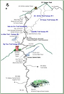

 It is asphalt paved throughout and several rain/picnic shelters are located along the way.You can find some stairs and railings along the way. We’ve parked the car here (parking lot at km 10.2) and we left on the trail. The La Mina Falls was nicer than La Coca; there were already some people in the small pool. After a few minutes we’ve decided to continue our exploration and moved on, up the river.
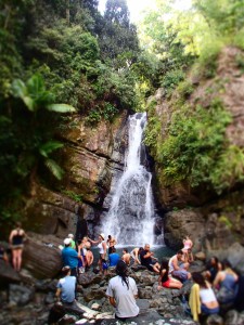
 From La Mina Falls, if you continue the road ahead you can find The La Mina trail witch is the most popular. The trail (witch starts at km 11.8) follows the course of the La Mina River downward through lush tropical trees, shrubs and flowers to the La Mina Falls. Along the way, it crosses and re-crosses the rushing river on many small bridges, passing tiny cascades and still pools filled with chilled mountain water, on its way to the falls. On this two trails there were a lot of tourists, of all ages, especially on our way back, so be sure to come early if you don’t wanna intersect to much with tours and other slow/noisy people… We started this trail at 10 o’clock. The the information center they said that the approximate time for those two trails is 35 minutes each (one way). We made it (both trails) in 50.
There is a barrier at km 8.1 at La Coca Falls witch closes at 18:00, so be sure to exit before that, unless you are planning to stay up there over night! We’ve seen some small camping places, but i think you need a permit for that.
The first two stops on the road are very easy to reach from the car. First, La Coca Falls, on the right side of the road at km 8.1. Nothing fancy. Then, a little more way up (km 8.9), there is a tower on the left side. You can go to the top where you can have a beautiful view over the forest. At the base they also have some souvenir shop and some refreshments.
A couple km after this you can find the parking for “Big tree” trail and “La Mina” trail.The Big Tree Trail is a 0.7 miles (1.4 km) self-guided interpretive trail, descending from 1,804 feet (550 meters) to 1,640 feet (500 meters). Hiking time is approximately 35-40 minutes, one-way. The trail is rated as moderate in difficulty (I’d say easy), and is steep in some places.
At the end of this trail you’ll exit a couple km up the road (km 11.8) where you can find a parking lot, rest area, gift shop and restrooms.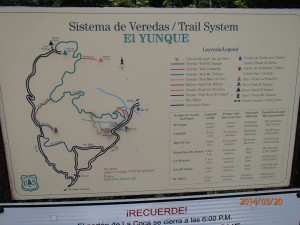
 This is also the starting point for other trails, Baño De Oro, Caimitillo and El Yunque trail. We did the last one.
The trail begins at the concrete steps across from the visitor center, leading to the Baño Grande pool. At the top of the steps the trail turns right and proceeds along the Caimitillo trail for approximately 150 feet to the El Yunque trail junction (marked by a Forest Service sign). Continuing on, you’ll pass through the lush canopy of the Palo Colorado forest into the higher elevations of the Mountain Palm (Palma Sierra in Spanish) forest, eventually reaching the mysterious, ever-clouded Dwarf Forest at the trail’s end. Trail surface is a composite of asphalt, gravel and native stone, and can be muddy in places. There is a rain shelter mid-way along the first half of the trail. Estimated time from the information center: 2 hours. Our time: 1 hour 20 minutes.
Unlike the other day, here you can find signs for every trail, you can’t miss the path. We’ve seen just a few people on this trail, much less than on the previous two. The trail is well maintained, they were even doing some works along it, fixing the stairs and draining tubes. At the end of it, the satisfaction is guaranteed, the view from the top is awesome. Just before reaching the peak of El Yunke, on the right side of the road, 10 steps away you can climb (be careful, it might be deadly if you fall) a cliff from where the view makes you feel in paradise.The green tropical forest underneath you bounded by the unreal blue beauty of the Caribbean sea and the wind gently touching your face gives you the sensation of “the world is mine”!
Walking a little more literally through the clouds, we’ve reached the peak of El Yunque. A small tower can be found here along with some communication antennas. I had the best AT&T network signal ever!
This was the only place where rain came, but luckily for us, it only rained on the other side of the forest and not for a long time.
Following the road back down, we made a small detour to the Mt. Britton lookout tower, witch was very similar with the first one on the road. The road is closed for cars at km 13. Heading back to the car we took once again La Mina trail, where we’ve stopped for a small bath in the river,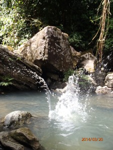
 and than Big Tree trail to finish from where we started this beautiful and amazing trip. It was around 17:00.
In conclusion, whenever you travel there, this is a part of Puerto Rico that you don’t wanna miss!
By Liviu • Travel • 0 • Tags: el yunque, forest, hike, hiking, puerto rico, rain forest, trail, tropical